by sentierschelseatrails | Oct 16, 2011 | Members & Volunteers

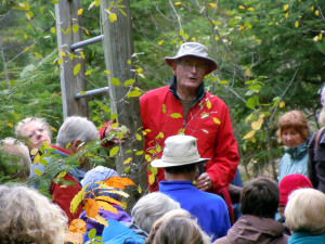
Alen Richens gives the history of the trails
We probably broke some record for trail traffic on Sunday, October 16, when more than fifty walkers and at least ten dogs joined Alan Richens for a historic walk along Chelsea’s trail system. The route began at the Municipal trail on Musie Road, travelled up the ridge and followed the chain of beaver ponds to end at the Larrimac Golf Course. This is the second family hike organized by Chelsea trails to introduce community members to another piece of the longstanding network of nature trails that wind through our neighbourhoods. The group walked for more than three hours, stopping along the way for Alan to explain the history of some of the routes that he has been walking and skiing for more than fifty years. Some of the trails were even named, by Alan and friends including the Northwest Passage the top end of Larrimac Golf course.
Thanks to George Rogerson and Heidi von Graevenitz for organizing the event. And there will be more! Chelsea trail will be planning more trail exploration outings in the future. Stay tuned
Posted by Roberta Walker
by sentierschelseatrails | Sep 14, 2011 | Members & Volunteers

Richard Garlick
Chelsea Trails has lost one of its founding members to cancer.
Richard Garlick was a person who lived his passions and one of them was Chelsea’s network of trails. . He skied them in the winter every chance he got. And in the Spring and Fall, he groomed and walked them, and just simply loved them.
He lived in the Ridge Group and was the unsung trail steward for the neighbourhood’. After 25 years in the neighbourhood, things inevitably changed, new houses were built and the trail system eroded as the neighbourhoods began to fill up with houses.
He along with a number of his close friends lamented the dwindling trail system until one day, a few Chelsea residents decided to hold a meeting and see if there was any interest in creating an official organization to build Chelsea trails into the future of our Municipality. This idea ignited Richard and propelled him into all the actions, meetings, and emails that eventually launched Sentiers Chelsea Trails. Once he had gotten things going, he had to turn all his energy towards his own health. Unfortunately, that boundless energy for ideas and life was eventually consumed by his cancer and he died in June of this year.
He would be amazed to see the momentum he started and we will all be touched by his memory as we travel the trails…..thank you Richard for leaving us with a legacy for future generations.
by sentierschelseatrails | Feb 1, 2011 | Members & Volunteers

Called Indian Lookout in the 1940’s, this viewpoint off Musie Road is part of the trails land owned by the Municipality.
Chelsea is endowed with a rich network of informal trails that have been here since before the mid-1800s. Originally these were wagon trails or foot paths providing Chelsea’s rural residents with access to the Gatineau River and to the railway line that moved passengers and freight north and south. For example, the trail from Larrimac Golf Club to Meech Lake was originally called Cooper’s Trail. Known today as the Wood Trail, this route splits into three parts at O’Rourke’s clearing—one branch ending at Cowden Road, near Pine Road, in the Meech Creek Valley, another crossing Meech Creek at the ruins of Thomas “Carbide” Willson’s fertilizer mill, and a third emerging at what was the Dunlop Farm at Meech Lake road. All these trails were essential to allow homesteaders to move about in the community
In the early part of the 20th Century—with the advent of motorized vehicles and improved road access—these old settlers’ trails found new uses among individuals looking for a challenging recreational experience, such as hiking and skiing, or simply for a way to get closer to the natural beauty of the area. In the years following the First World War, cross-country ski touring in the Gatineau hills became extremely popular, thanks in large measure to the efforts of the Ottawa Ski Club. Skiers would travel by train (or, after the mid-1920s, by bus) to destinations such as Kingsmere, Tenaga, Ironside or Kirk’s Ferry where they could access an extensive network of trails connecting to other villages, or to one of several ski lodges that began springing up in the 1920s.
(more…)
by sentierschelseatrails | Feb 1, 2011 | Members & Volunteers
A group of Nepean High school students volunteered their time to CT to begin the labour-intensive process of GPS data collection. This data will be used to map the existing trail inventory and assess the status of the trail as existing, secured, at risk or protected. This is the first step in CT’s work to build a master plan for the trail network.


Recent Comments