Early Chelsea Dwellers Left Legacy of Trails

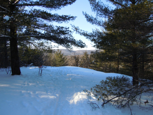
Called Indian Lookout in the 1940’s, this viewpoint off Musie Road is part of the trails land owned by the Municipality.
Chelsea is endowed with a rich network of informal trails that have been here since before the mid-1800s. Originally these were wagon trails or foot paths providing Chelsea’s rural residents with access to the Gatineau River and to the railway line that moved passengers and freight north and south. For example, the trail from Larrimac Golf Club to Meech Lake was originally called Cooper’s Trail. Known today as the Wood Trail, this route splits into three parts at O’Rourke’s clearing—one branch ending at Cowden Road, near Pine Road, in the Meech Creek Valley, another crossing Meech Creek at the ruins of Thomas “Carbide” Willson’s fertilizer mill, and a third emerging at what was the Dunlop Farm at Meech Lake road. All these trails were essential to allow homesteaders to move about in the community
In the early part of the 20th Century—with the advent of motorized vehicles and improved road access—these old settlers’ trails found new uses among individuals looking for a challenging recreational experience, such as hiking and skiing, or simply for a way to get closer to the natural beauty of the area. In the years following the First World War, cross-country ski touring in the Gatineau hills became extremely popular, thanks in large measure to the efforts of the Ottawa Ski Club. Skiers would travel by train (or, after the mid-1920s, by bus) to destinations such as Kingsmere, Tenaga, Ironside or Kirk’s Ferry where they could access an extensive network of trails connecting to other villages, or to one of several ski lodges that began springing up in the 1920s.

Recent Comments