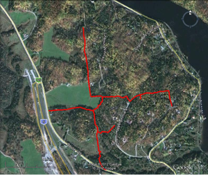
In the northern most sector of the Municipality of Chelsea – in a triangle of wooded land bounded on the west by Route 105, on the east by the Gatineau River, and on the north by the border between Chelsea and LaPeche – exists a substantial network of informal trails and walking paths. Most of these trails are located on relatively large tracts of private property – land owned by individual land owners or in some cases by numbered companies. These trails are generally not well known and are used by local residents with the unspoken and assumed consent of property owners. These trails provide a glimpse into Chelsea’s past, providing access along long-forgotten bush roads, old fence lines, and abandoned mica mines dating back to the 1890’s. They represent a small part of Chelsea’s heritage – just one portion of the larger network of such trails scattered throughout the municipality.
But change is coming – and fast.
Click here to read the whole article.


Recent Comments